In short
At the foot of the hill, south of the centre, a south roof loses about 3.6% of its yearly output to the land and about 32% in December. On Main Street, on Overton and towards the marshes the loss is close to nothing. Under the hill, west and south-west slopes lose little or nothing, because the ridge rises to the south-east.
The town under the ridge
Cheshire’s planners described Frodsham in 2006 as lying close to drained marshland, “below the spring-line of a scarp slope to an adjacent sandstone ridge upon which a pre-historic hill fort was established” (Frodsham (Town) appraisal). The ridge runs along the south side of the town, and Overton sits up on its slope. For most of the year it is scenery. For a few weeks either side of the shortest day it is a wall between some homes and the sun.
What we ran
PVGIS 5.3 can include the horizon formed by the surrounding land, worked out from a terrain grid. We ran 1 kWp at a 35° pitch, with 14% losses, at four points in Frodsham, once with the terrain and once without, and asked PVGIS for the horizon profile at each. The points are illustrative: they stand for kinds of location, not for any one street.
| Where | Highest land to the south | Year, with land | Year, open sky | December, with land | December, open sky |
|---|---|---|---|---|---|
| Main Street | 8° | 942 | 942 | 27.9 | 28.3 |
| Foot of the hill, south of the centre | 17.2° | 908 | 942 | 19.1 | 28.3 |
| Overton, near the top of the ridge | 1.1° | 942 | 942 | 28.3 | 28.3 |
| North of the centre, towards the marshes | 4.2° | 943 | 943 | 28.2 | 28.2 |
Only one row stands out. At the foot of the hill a south roof gives up about 3.6% of its year and about 32% of its December. The other three points lose a fraction of a per cent or nothing.
The shortest day
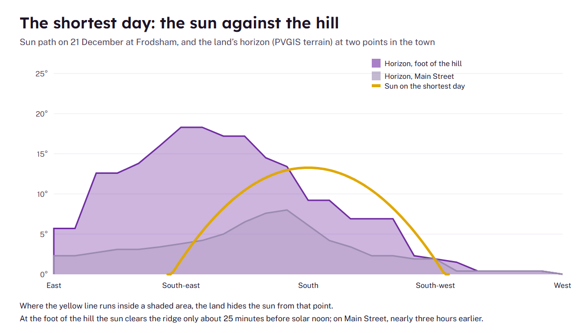
The reason is geometry. At Frodsham’s latitude the midsummer sun reaches about 60° at noon; on the shortest day it reaches only about 13°, and it rises in the south-east. From the hill foot the land stands about 18° high to the south-east and about 9° due south. Working through the sun’s position minute by minute against that horizon, the midwinter sun clears the ridge there only about 25 minutes before solar noon. On Main Street, a few hundred metres north, it clears the land nearly three hours earlier. That is our reading of the PVGIS horizon using standard sun-position maths; the terrain is coarse, so treat the times as approximate.
Which directions suffer
| Roof faces | Hill foot | Overton | Lost to the land |
|---|---|---|---|
| south | 908 | 942 | 3.6% |
| south-east | 842 | 885 | 4.9% |
| south-west | 879 | 891 | 1.3% |
| east | 715 | 746 | 4.1% |
| west | 753 | 753 | 0.0% |
Because the ridge is highest to the south-east, morning-facing roofs lose most and afternoon-facing roofs least. Under the hill, a west-facing slope loses nothing in our runs. If your house has a choice of slopes, that changes which one to use: east and west roofs works through it.
How local the effect is
The hill’s reach is short. Our Main Street point, about half a kilometre north of the hill-foot point, loses 0.4 kWh per kWp a year to the terrain on a south roof: less than one unit in a thousand. The hill-foot point loses 34 kWh per kWp, about 3.6%. Up on Overton the southern horizon is almost flat and the loss is nil. So two houses a few streets apart can sit on either side of the line, and a neighbour’s figure is no guide to yours.
The hill also matters more than the weather for those houses. PVGIS puts the normal year-to-year swing in Frodsham’s output at about 28 kWh per kWp (PVGIS 5.3). At the hill foot the ridge takes 34 kWh off a south roof every year, good year or bad, which is more than that swing. A quote for a house close under the ridge that uses the open-sky figure is out by more than a dull summer would explain; ask the firm whether its estimate allows for the horizon, and if it does not, compare it with the output tables instead.
What the model cannot see
- Trees. The wooded slopes of the ridge and the lime trees in the town’s streets are not in the terrain grid. See trees and shade.
- Buildings. The house opposite, a chimney or an extension can shade more than the hill does.
- Your exact spot. The grid is about 90 m across, so two houses on the same street can sit differently against the slope.
What to do with it
- Use the hill-shade checker to see the likely range for your kind of location.
- Ask any firm for an MCS performance estimate with a shade assessment made at the house, and ask to see the December figure as well as the year (MCS).
- If you are under the hill, weigh a west or south-west slope, and be cautious about sizing a battery around winter output.
- Check the planning position: Overton has two conservation areas, and the town centre and Castle Park have their own; see the four conservation areas.
For the full open-sky table see output in Frodsham. To ask about a particular house, use the question form.